“Old versus new”? You don’t even have a clue. Humans have always been interested by the progression of time, whether that’s in philosophy, in music, or waiting at the DMV. Jokes aside, many people take interest in the physical changes of things as time progresses. There are even multiple subreddits and communities dedicated to it and we’ll admit, it’s a lot more interesting to see it than hear about it. For all you visually-inclined folks, you’re in for a treat.
Today, we’re focusing less on the DMV and more on geography. Specifically: cities! Here’s a surprisingly fascinating look into the progression and development of well-known cities, portrayed by stunning maps. See more for yourself below.
Dresden, 1899 VS Today

Built upon both banks of the Elbe River, the center of Dresden is divided into the Altstadt (old city) in the south and the Neustadt (new city) in the north. For centuries it was hailed as a center of European culture, but much of the city was destroyed during WWII due to Allied bombing and the firestorm that followed.
The city has since been rebuilt and restored, yet WWI’s legacy still hangs over it.
- Located In: Saxony, Germany
- Area (km sq.): 328.8
Karlsruhe, 1845 VS Today

Notable for its fan-shaped layout, Karlsruhe is a city in southwestern Germany that lies on the northern edge of the Black Forest. Originating in 1715 with the construction of a palace that acts as the city’s focal point, Karlsruhe has long been a distinguished exemplar of the Baden region and culture.
Though much of the city has grown outward over the last 300 years, the city’s unique layout can still be seen today.
- Located In: Baden-Württemberg, Germany
- Area (km sq.): 173.46
Amsterdam, 1893 VS Today

Founded as a fishing village near a dam in the Amstel River during the 1200s, Amsterdam cemented itself as the center of the world’s economy during the city’s golden age in the 16th and 17th centuries. Much of the city is built upon its famous canals, reflecting the Dutch Republic’s history as a naval mercantile empire.
Although many of the city’s oldest buildings fell into disrepair after French occupation and economic recession in the late 1700s, some facades from the golden age still survive in the city center. Amsterdam recovered during the 19th and 20th centuries and today is one of Europe’s top tourist destinations.
- Located In: North Holland, Netherlands
- Area (km sq.): 219
Columbus, 1873 VS Today

Intentionally planned to be the political center of Ohio, Columbus was designed by the Ohio legislature starting in 1812, then established along the junction of the Scioto and Olentangy rivers in 1816. Over the course of the 19th century the city continued to grow and eventually became a major staging area for Union forces during the US Civil War.
In the 20th century, the city boomed exponentially as a major industrial center.
- Located In: Ohio, USA
- Area (km sq.): 577.85
Glasgow, 1888 VS Today

Although the official city did not develop until about 550 CE with the arrival of St. Kentigern (Mungo) along the River Clyde, Glasgow (deriving from the Gaelic name Glaschu, meaning “Green Glen”) was built upon what became a very important geographical location. Situated between Highland and Lowland Scotland as well as between Scotland’s capital Edinburgh and the West, Glasgow grew and prospered as a key port between the Americas and the United Kingdoms of Scotland and England.
Glasgow went through difficult times between the 18th and 19th century as a result of levies and city occupation by Charles Edward Stuart, and wars in the Americas disrupted trade, but the city developed into a ship and heavy industry manufacturer during the Industrial Revolution. Glasgow’s industry suffered greatly, however, after WWI, garnering the city some notoriety. Even though the city has since recovered and even prospered as an important financial and cultural hub, it’s still trying to shake off its “hard man” reputation.
- Located In: Strathclyde
- Area (km sq.): 175.5
Strasbourg, 1845 VS Today

Situated on France’s border with Germany, Strasbourg sits upon the Ill river and blends French and German influences. The city lies within a fairly contentious area, however, and throughout its long history, has consistently changed hands between dominant powers of Western Europe – including the Romans, the Franks, the Holy Roman Empire, Germany, and France.
Today, the city’s old town is situated on the Grand Île, which is surrounded by a division of the Ill River. This part of the city was designated a UNESCO World Heritage site in 1988.
- Located In: Bas-Rhin, France
- Area (km sq.): 78.26
Buffalo, 1864 VS Today

Though it is currently New York’s second largest city, Buffalo began from very humble origins. A French trading post along the Niagara River in 1758, it was destroyed and resettled multiple times over the subsequent 50 years. It began to expand greatly during an economic boom in 1825 with the construction of the Erie Canal and continued to grow rapidly as it became a center of trade during US westward expansion. Buffalo, today, still acts as a major crossroad for many American transit and trade systems.
- Located In: New York, USA
- Area (km sq.): 136.0
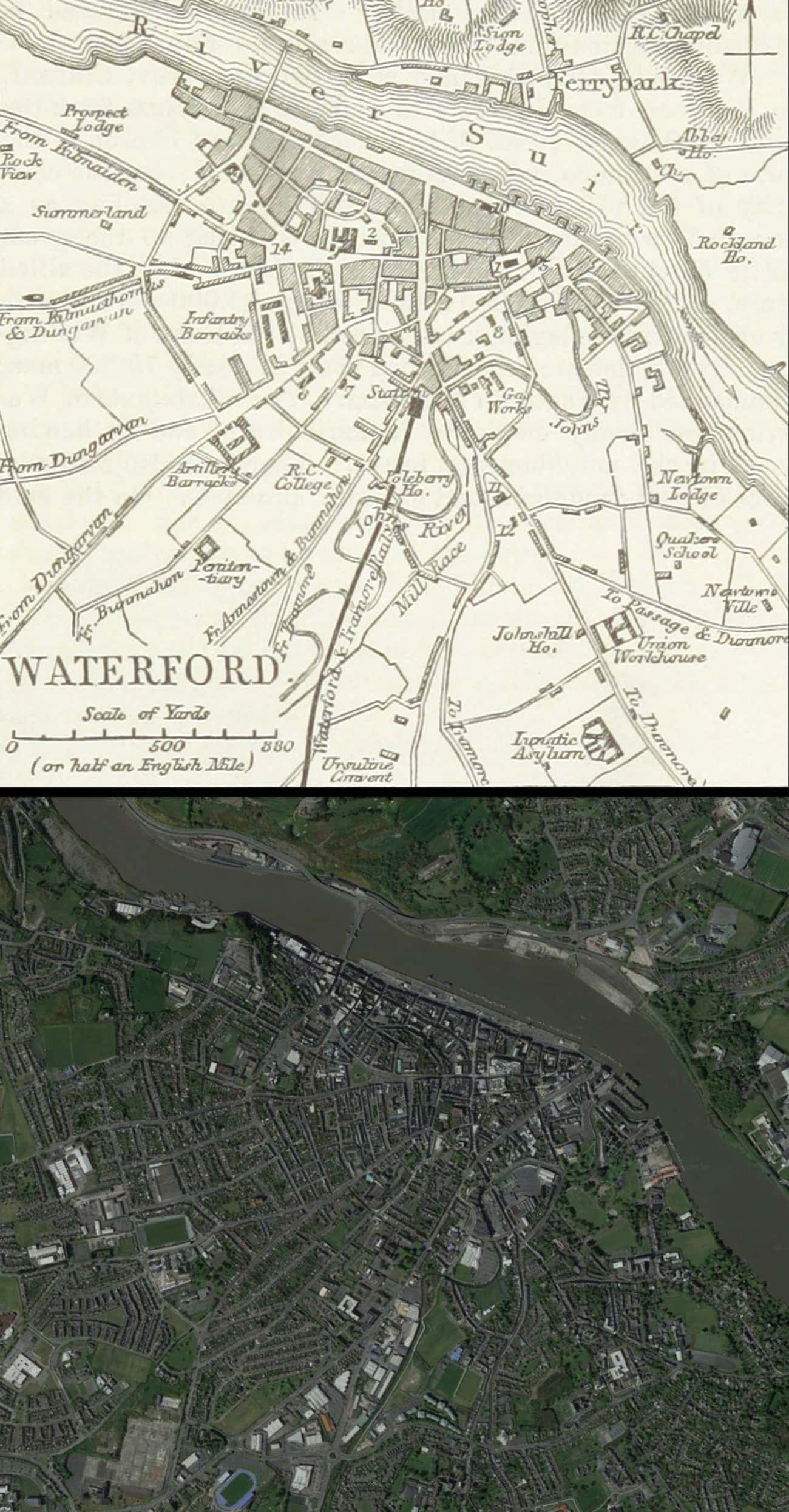
Waterford, 1874 VS Today

Established by the Vikings in 914 CE, then conquered by the Normans in the 12th century, Waterford is Ireland’s oldest city. Due to its location on the southeastern end of the Republic of Ireland along the River Suir, the city has had a fairly extended history as a cultural and economic link between mainland Europe and the rest of Ireland.
- Located In: County Waterford, Republic of Ireland
- Area (km sq.): 41.58
Rome, 1845 VS Today

Said to have been founded in 713 BCE by the legendary Romulus along the river Tiber, Rome has long been a key Mediterranean city. Through its more than 2,800-year history, the city of Rome has been the capital of multiple kingdoms, a Republic city-state, the seat of power of an empire named after it, and the home of the papacy for the Catholic Church. Although Rome’s golden age was during the era of the Roman Republic and the early Roman Empire, the city has had many rises and falls.
Despite the city’s sacking during late antiquity, its collapse in 476, the eventual loss of papal control during the Great Schism in 1305, and its conquest and looting by the armies of Napoleon, Rome continues to show off its long historical heritage today as the capital of Italy.
- Located In: Lazio, Italy
- Area (km sq.): 1285.31
Santo Domingo, 1874 VS Today

Founded in 1496 by Bartholomew Columbus, brother of Christopher Columbus, Santo Domingo in the Dominican Republic was the capital of the first Spanish colony in the New World. Although the original city site was built on the east bank of the Ozama River, it was destroyed by a hurricane and rebuilt in 1502 on the west bank and expanded from there. Santo Domingo continued to be a key city during the Spanish colonial era as a starting point for many Spanish expeditions throughout the West Indies and acted as the Empire’s New World seat of government until the conquests of Mexico and Peru.
The city struggled after the late 16th century as a target of sacking and conquests by multiple nations until the Dominican Republic gained independence in 1865. Santo Domingo is the Domincan Republic’s industrial, commercial, and financial center, but the city has grown greatly since the late 20th century as a tourism destination.
- Located In: Hispaniola
- Area (km sq.): 104.44
Charleston, 1867 VS Today

Established as one of the earliest English colonial cities in North America, Charleston (or Charles Town when it was settled in 1670) became one of the 13 original colonies’ busiest seaports by the mid-1700s. Although the city went through its economic golden age before the American Revolution as a critical port for exporting goods, It continued to prosper through the 1800s. Charleston went through difficult times in the 1860s, however, when South Carolina became the first state to secede from the Union preceding the US Civil War.
Charleston became a key city during the conflict and was a target of siege and bombardment. The city’s struggles continued through Reconstruction, but it was rebirthed as a cultural center during the 1920s amid the Charleston Renaissance. Due to a preservation effort that began in the 1940s, many of Charleston’s old buildings remain, and the city serves as a “living museum.”
- Located In: South Carolina, USA
- Area (km sq.): 405.5
Pondicherry, 1878 VS Puducherry Today

Puducherry, formerly known as Pondicherry, has grown and changed immensely since its founding as a colonial settlement by the French East India Company in 1674, yet its colonial origins can still be seen today in the old “French” part of town, marked most noticeably by its gridded street.
Today, Puducherry is renowned as a seaside tourist resort town on the southeastern coast of India, as well as the administrative center for the entire Puducherry union territory.
- Located In: India
- Area (km sq.): 492.0