Thousands of natural wonders exist in the world. But have you ever wondered about the history behind them? Some of these amazing formations and events date back millions of years, while others are less than 100 years old. There are legends and theories attached to how some of them came into existence, but what are the actual scientific explanations? And while climate change is a major topic in the 21st century, what role did this play in the formation of these natural wonders, and how has it affected them in the years since they were formed?
1. Reefs First Appeared In The Region Millions Of Years Ago, But The Current Structure Of The Great Barrier Reef Is 6,000 To 8,000 Years Old
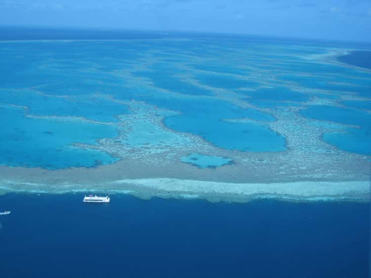
Located in the Coral Sea off the coast of Queensland, Australia, the Great Barrier Reef is the world’s largest coral reef system. It is made up of more than 2,500 individual reefs and 900 islands that form a chain that stretches for more than 1,429 miles. It is so massive that it can even be seen from outer space.
The history about how the reef was formed is complicated. It is thought that coral reefs first began to appear in the region between 58 and 48 million years ago, when the Coral Sea Basin was formed. However, as the continent of Australia shifted to its current location, the change in sea levels and climate caused these reefs to grow and decline in cycles.
Scientists think a complete coral reef structure formed in the location of the current Great Barrier Reef some 600,000 years ago, but died off due to climate change and shifting sea levels. The belief is the current reef began to form on top of the remains of the older structure around 20,000 years ago. Then as the sea level continued to rise and the coastal plain was flooded, the coral reefs began to grow on the hills.
About 13,000 years ago, the sea level was about at the point where it stands currently, and as islands off the coast began to submerge, the coral reefs began to grow over them, forming the structure of the current Great Barrier Reef. Scientists believe the current structure finished being formed 6,000 to 8,000 years ago.
2. The Salar de Uyuni Formed When Prehistoric Lakes Dried Up Over Thousands Of Years
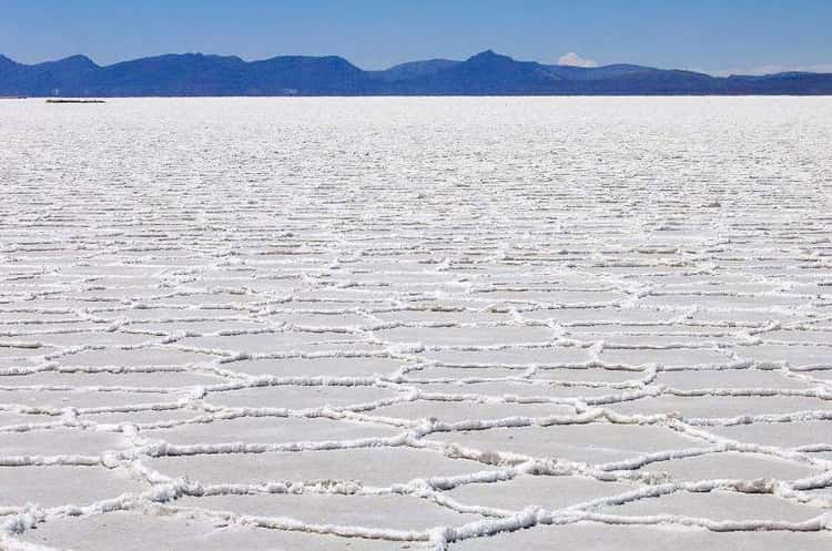
Located within the Altiplano in Bolivia, this natural wonder covers around 3,100 square miles, making it the largest salar – or, in English, salt flat – in the world. The Altiplano itself is a high plateau formed during an uplift of the Andes Mountains. In addition to salt flats, the plateau is home to both freshwater and saltwater lakes.
Around 30,000 to 40,000 years ago, this area was part of a giant lake called Lake Minchin, which then transitioned to Paleo Lake Tauca anywhere from 13,000 to 26,100 years ago. When Paleo Lake Tauca dried up, it left behind two smaller lakes that still exist – Poopó and Uru Uru – and two salt flats – Salar de Coipasa and Salar de Uyuni. During the rainy season, the larger Lake Titicaca overflows into Lake Poopó, which in turn floods the two salt flats.
Some estimates claim the Salar de Uyuni contains as much as 10 billion tons of salt. The crust that covers the salt flat is made up mainly of the minerals halite (table salt) and gypsum. For the most part, the crust is just a few feet thick, but it can be as thick as 30 feet in some spots. And although it is called a “salt flat,” the Salar de Uyuni is not completely flat.
3. When The Indian Subcontinent Charged Towards Asia At A Great Speed, The Two Tectonic Plates Began To Form Mount Everest
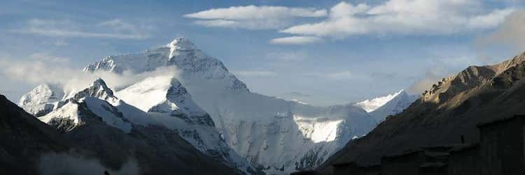
More than 250 million years ago, what we now know as India, Africa, Australia, and South America were all part of one large continent known as Pangea. Over the next many millions of years, Pangea began to break up into separate continents.
For at least 80 million years, India moved northwest at a rate of as much as 15 cm/year, carried along by a tectonic plate sliding along the surface of the Earth, driven by the internal heat found deep inside the planet. Around 60 million years ago, India collided with the continent of Eurasia, which was traveling on its own tectonic plate. When the two plates collided, the sinking ocean floor led to volcanic activity in southern Tibet, which caused the rock at the top of the descending plate to melt.
Then 25 million years ago, the Indian continent had nearly entirely closed over the ocean between it and Eurasia, squeezing the sediments on the floor of the ocean. But because these sediments were lightweight, they did not sink along with the tectonic plate. Instead, they ended up forming the mountain range now known as the Himalayas – which, of course, includes the majestic Mount Everest.
4. Victoria Falls Began Developing As The Zambezi River Flowed Through Huge Cracks In A Plateau
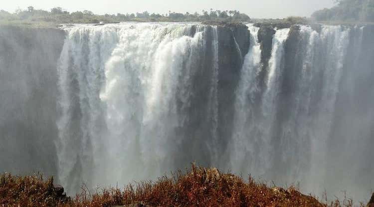
Located on the border of Zambia and Zimbabwe, Victoria Falls – or in the Sotho language Mosi-oa-Tunya (“the smoke that thunders”) – is classified as the world’s largest waterfall based on its combined width and height. Scottish explorer David Livingstone named this natural wonder Victoria Falls after Queen Victoria of England when he discovered the waterfall in 1855 during his travels through Africa.
Changes in the river systems in this area of Africa are what led to the eventual formation of Victoria Falls. Millions of years ago, the area around where the falls presently exist was covered by molten lava, which, when cooled, formed wide cracks or joints that became filled by softer sediments.
Meanwhile, the upper Zambezi River originally drained south through current-day Botswana where it joined the Limpopo River, while the lower Zambezi River had a separate outlet into the Indian Ocean. But about 2 to 4 million years ago, seismic shifts resulted in parts of the area around where Victoria Falls is now located to be raised up. This uplift ended up blocking the upper Zambezi River’s southern drainage route.
When the river encountered one of these joints formed by the cooled lava, the water pressure eroded the soft sediment and created a trench. As time passed, the lower end of the trench widened into a large gorge into which the river falls. The force of the water also created another gap at the top of the trench that diverted the river until the trench was left dry. As the Zambezi doubled back time and again, it ended up carving out eight separate waterfalls that made up the present Victoria Falls.
5. The Eruption Of Parícutin Allowed Scientists To See The Entire Life Cycle Of A Volcano In Just Nine Years
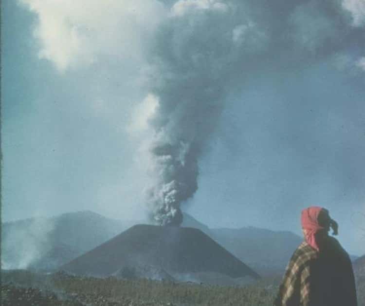
“When night began to fall, we heard noises like the surge of the sea, and red flames of fire rose into the darkened sky, some rising 2,600 feet or more into the air, that burst like golden marigolds, and a rain like artificial fire fell to the ground.”
That rather poetic account is how a local farmer named Celedonio Gutierrez described the events of February 20, 1943, when ground near the village of Uruapan, Mexico, rose more than 6 feet, spewing ash and vapors into the air. As the night went on, a cone of ash began to form on the site of the eruption. This marked the birth of the volcano known as Parícutin.
Named after a nearby village, Parícutin eventually rose to a height of 1,391 feet. After the ash had formed a 1,000-foot-high cone, lava began to pour out, burying the village of San Juan Parangaricutiro so thoroughly the only thing left visible was a church steeple poking out of the rocks. Luckily, the area was evacuated without anyone perishing.
The birth of Parícutin attracted enormous attention: Flights from Los Angeles to Mexico City would divert from their routes in order to give passengers a glimpse of the ongoing activity. Scenes for the 1947 film Captain from Castile were filmed in the area around the active volcano. And William Foshag, a mineralogist working for the US National Museum, documented the growth of Parícutin one month after its emergence.
The volcano continued to erupt until March 1952, when its activity halted just as abruptly as it had begun.
6. The Giant’s Causeway Was Created When Molten Lava Cooled, Contracted, And Cracked When It Reached The Sea
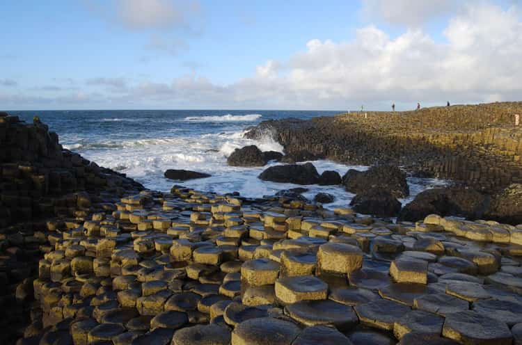
On the north coast of Northern Ireland, about 3 miles northeast of the town of Bushmills, stands a structure of around 40,000 interlocking black basalt columns, most of which are hexagonal in shape. The tops of the columns serve as steps that lead from the cliff to under the sea.
One legend holds that this causeway was built by an Irish giant by the name of Finn MacCool as a way to allow him to cross into Scotland so he could confront one of his rivals. Sadly, the scientific explanation for how the structure came to be isn’t as fanciful.
According to researchers, the Giant’s Causeway was formed between 50 to 60 million years ago when molten lava flooded through fissures in the earth. Scientists knew at that time in history, this area of Northern Ireland had experienced heavy volcanic activity. And they were aware when the lava cooled and contracted, it cracked and formed the columns that formed the causeway.
But for centuries, no one knew at what temperatures this phenomenon occurred. Until 2018, when scientists re-created the process and determined the basalt would have fractured and formed columns at between 840 and 890 degrees Celsius (between 1,544 and 1,634 degrees Fahrenheit).
7. The Aurora Borealis Lights Up The Skies When Particles From The Earth And The Sun’s Atmospheres Collide
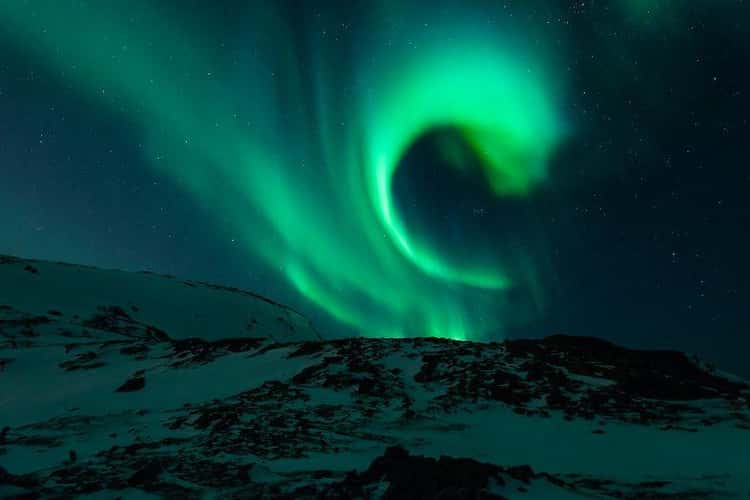
Perhaps sadly to some, these bright, colorful lights that dance across the sky are not some sign of alien activity. However, there are several legends attached to the phenomenon. In medieval times the lights were seen as a sign of coming war or famine. The Menominee tribe of Wisconsin believed the lights showed the location of “manabai’wok” (giants) that were the spirits of great hunters and fishermen. And some aboriginal groups thought the lights were the spirits of their own people.
Commonly known as the northern lights, an aurora borealis (“dawn of the north”) – which are seen in the Northern Hemisphere – or aurora australis (“dawn of the south”) – which are seen in the Southern Hemisphere – actually occur when electrically charged particles from the sun’s atmosphere collide with gas particles in the Earth’s atmosphere.
Pushed along by solar winds, most of these particles from the sun are deflected by the Earth’s magnetic field. But above the poles of the Northern and Southern Hemispheres, the magnetic field is weaker, which allows some of the particles to escape into the Earth’s atmosphere. When they collide with gas particles – boom! – the result is this brilliant display of light.
The color of the lights varies depending on what type of gas particle is involved. The most common are yellow-green lights, which are caused by a collision with oxygen molecules about 60 miles above the Earth. Less common are blue or purplish-red auroras, which are formed by nitrogen molecules, and all-red auroras, which are caused by high-altitude oxygen molecules.
Researchers have discovered that this type of auroral activity is cyclic, peaking roughly every 11 years – which means the next peak period should be in 2024. In North America, the best place to see the lights would be in Alaska and the northwestern parts of Canada, although in the past they have been seen as far south as New Orleans.
8. The Sahara Desert Was Born Some 7 Million Years Ago When The Vast Tethys Sea Closed Up And Dried Out
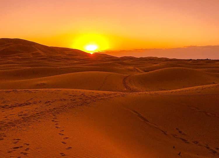
The Sahara in North Africa is the world’s largest nonpolar desert. For many years, the consensus among scientists was the desert had been formed some 2 to 3 million years ago. But in 2014, researchers at Norway’s Bjerknes Centre for Climate Research ran simulations of the climate changes that have taken place in North Africa over the last 30 million years, and the findings suggested the Sahara is probably at least 7 million years old.
Using data involving changes in the Earth’s orbital position, the ratio of land to ocean as caused by tectonic action, and atmospheric chemistry, the simulations showed the level of precipitation in North Africa dropped by more than half about 11 million years ago, which caused the region to dry out. By process of elimination, the conclusion reached by the researchers was that it had been tectonic forces that had caused this change.
Some 250 million years ago, a gigantic body of water called the Tethys Sea had separated the supercontinents of Laurasia and Gondwana. But as those supercontinents broke apart and the African tectonic plate collided with the Eurasian one, this closed off much of the Tethys Sea. And this once huge body of water continued to get smaller and smaller as the tectonic plates continued to move and shift.
The movement of these plates led to the western arm of the Tethys Sea to be replaced by the Arabian Peninsula somewhere between 7 to 11 million years ago. With land replacing water, the precipitation levels in the region declined drastically, which in turn resulted in the Sahara being created.
9. The Grand Canyon Could Have Been Carved Out As Recently As 6 Million Years Ago, But The Rocks Have Been Around For 2 Billion Years
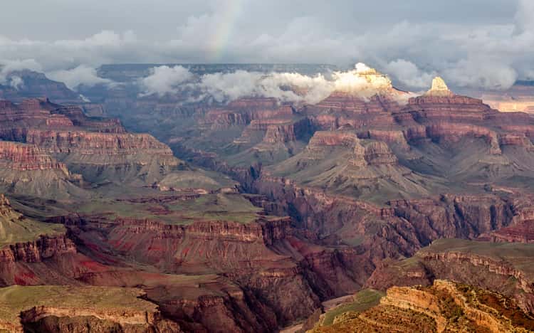
Located in Arizona in the Western part of the United States, the Grand Canyon is 277 miles long, has a width of up to 18 miles, and is more than a mile deep.
The actual age of the Grand Canyon is highly debated. In 2012, a study published in Science Magazine suggested it could be up to 70 million years old. Other geologists and researchers claim it was formed closer to 6 million years ago.
Less contentious is the belief the canyon’s beginnings can be traced to about 2 billion years ago when the igneous and metamorphic rocks that can now be seen at the bottom of the canyon first began to be formed. Over the years, layers of sedimentary rocks were piled on top of these bottom rocks. The Kaibab Limestone, the top – and, at 270 million years old, youngest – layer of rocks of the Grand Canyon, was formed at the bottom of the ocean, but its current elevation is as high as 9,000 feet above sea level.
It reached this elevation through the action of plate tectonics, which resulted in the uplift and flattening of the Colorado Plateau. The consensus is this occurred during a mountain-building episode called the Laramide orogeny, which began about 70 million years ago and lasted until about 40 million years ago.
Millions of years later, as the Colorado River and its tributaries began to wind its way down through the plateau, the Grand Canyon was formed. Geologists call this way of forming a canyon “downcutting.” This occurs during flooding and involves the water cutting down into the earth and eroding away the rocks.